Can you imagine how difficult travel between Akron and Cuyahoga Falls was in the early 19th century? People had to travel a long way around the gorge to find moderate crossings of the Cuyahoga River.

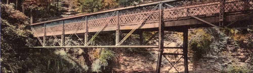
This changed when the electric streetcar route was extended from downtown Akron to Cuyahoga Falls using the High Bridge that was built in 1876. By 1894 the Akron and Cuyahoga Falls Rapid Transit began using the bridge as part of

the Akron to Silver Lake Route. It was known as the Mountain Line and was the major connector for both sides of the gorge.
A second bridge was built prior to 1895 where John Seiberling added street car tracks to the bridge and ran his competing streetcar up the west side of the river into downtown Cuyahoga Falls. By 1902 Seiberling’s company became the Northern Ohio Traction & Light Company and they built a new state-of–the- art two-track bridge 100 feet above the river.

In 1912 the wooden parts of that bridge were replaced by steel. Around 1932, after streetcar use ceased, the bridge was used for north-bound car traffic and the lower bridge carried south-bound cars.
In 1930 Front Street was straightened, eliminating a dangerous curve on the Cuyahoga Falls side and in about 1980 the lower bridge was rebuilt for traffic going both directions. The high bridge was removed.

Footbridge Abutment and Pier

Historic photographs show a pedestrian bridge crossing the Cuyahoga River a few yards below the dam. All that remains of this bridge are an abutment and a pier located on the south side of the river near the penstock piers. However, the bridge was an important connection for people. It allowed people to walk along the Chuckery from the High Bridge Glens and Caves Park and follow the hillside down to this bridge to be connected with the trails to Big Falls and Old Maid’s Kitchen. In 1912, when the power plant was completed on Front Street and the Chuckery channel to the west was filled for a railroad spur to build the Hydroelectric Plant, the connection was lost. People still used it to get across the river and go to the base of the river at the dam where a small part of the Big Falls is still visible. The bridge was removed by the Akron Metropolitan Park system in the 1930s.
