Overview
Welcome to the Large Branchiopod Google Earth Database! This page provides a link to download a database containing location information for large branchiopods from around the world. The very broad distribution of large branchiopods (down to the species level) necessitates a global view of these critters, and this database is designed with this in mind. You will need to get a free copy of Google Earth, which can be downloaded at this web site: http://earth.google.com/. Once you have this program, you can follow the procedures below to download and display the Large Branchiopod Google Earth Database.
The database contains latitude/longitude information for a range of large branchiopod (Anostraca, Notostraca, and “Conchostraca”) species. The database was created and is maintained by Stephen C. Weeks. Thus, this initial version only has his data plus some data gleaned from the literature. Additionally, this early incarnation concentrates primarily on Spinicaudatan (and especially limnadiid) clam shrimp. However, the hope is to add to this database and enlarge the species coverage to include all of the large branchiopods, eventually.
The database so far includes species identifications, sex ratios, and if the information was taken from the literature, the reference to that published work. In the older publications, lat/long data was not taken by the authors. In these cases, the verbal descriptions of the collection site are included and the exact lat/long coordinate was only estimated using these verbal descriptions.
S.C. Weeks will gladly upload any new information that he is sent. Please include latitude/longitude coordinates (in decimal coordinates; e.g., Lat = 30.4891; Long = -100.4930), location name, species name, and sex ratio information (if known). I will eventually be attaching pictures of each species, so if you have a jpg image of the species, please send that along also.
SCW is maintaining this web site in his “spare time.” Thus, the timing of uploading of your information will entirely depend on how many others are sending information as well as the nuances of SCW’s schedule. Therefore please be patient after sending information!
Procedures for Downloading Large Branchiopod Database
The following instructions are patterned after those given on the AntWeb web site.
You must install Google Earth (a free program) before undertaking any of the below.
To access the Large Branchiopod Google Earth Database, you must add it to your version of Google Earth.
Start up Google Earth.
Next, go to the “Add” menu and choose”Network Link”
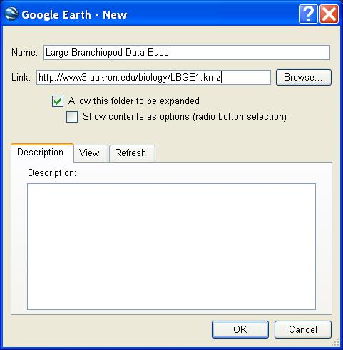
The above window will appear. In the “Name” box, enter “Large Branchiopod Database” (as shown above). In the “Link” box, add the following web address: http://www3.uakron.edu/biology/LBGE1.kmz. Then click on “OK.” If you have an older version of Google Earth, the box looks slightly different and instead of “Link” you are offered the choice of “Location.”
Once you have uploaded the database, you will see many “bulls eye” circles on Google Earth with a variety of place names. Most of these are in North America and Australia, at the moment, but there are a smattering of other locations. If you click once on the bulls eye, a box will pop up telling you more about the location. Double-clicking the bulls eye will zoom you into the location. The quality of the image you see after you zoom in depends on the quality of the satellite pictures stored in Google’s data base and has nothing to do with the Large Branchiopod data base!
Note that you may have quite a few other symbols showing up on your Google Earth screen. Google Earth defaults to quite a few place names and you may have selected several layers to be added to your screen. You can temporarilt get rid of these by simply de-selecting the check boxes next to the place names or layers to leave only the Large Branchiopod symbols, if you wish to un-clutter the screen.
On the left side of the screen, you will see the names and lat/long coordinates for all the locations in the database (in the “places” window). If you do not, go up to the main pull down menu bar, click on “Tools” and then “Places.” Double clicking on a name will direct Google Earth to that location.
At this early stage, the location names are eclectically labeled in Google Earth. As we update the database, we will organize these locations in a more hierarchical manner that will be more informative.
Note: sometimes when you close Google Earth and reopen it, it won’t load up the Large Branchiopod Database . If so, you will have to delete it and then re-add it using the above instructions starting at the “Add/Network Link”.
Next Steps
To make this data base most useful, we need to get input from the Large Branchiopod community. Thus, if you have location information that you are willing to share, please send me the above noted information and I will upload it and we can eventually produce a useful and informative GIS-style database for all to use!
Thanks in advance for your help.
Stephen C. Weeks